Eleven HHS members and friends took part in an enjoyable walk round Stroud Green on October 30th, starting at Finsbury Park Station.
The excellent weather gave us some splendid views from the vantage points of Finsbury Park and Mount View Road and the tour was enlivened by the reminiscences of several local members.
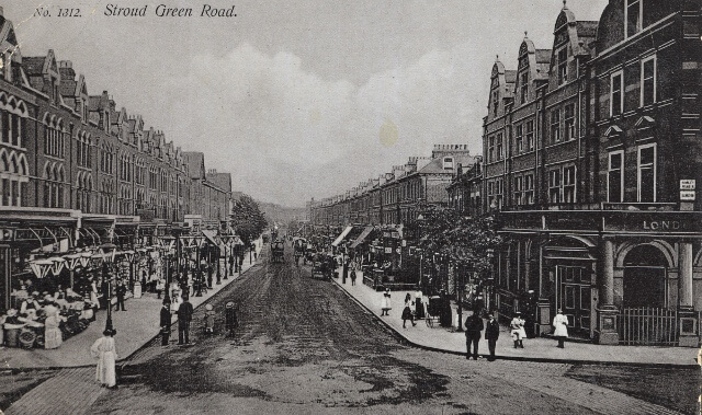
The old hamlet of Stroud Green was centred on what is now the junction of Stroud Green Road, Crouch Hill, Hanley Road and Stapleton Hall Road. Stapleton Hall, a plain, much altered, but probably basically 18th century house (now the Conservative Club) is the only pre-Victorian survival.

Early development
The area began to develop after the opening of the station on the Tottenham and Hampstead Junction Line at Crouch Hill in 1870, but most of the existing shops in the neighbourhood date from 1880 and later. The Old Dairy at the corner with its striking pictorial decoration of dairying ‘then & now’ probably dates from c.1888, when an existing dairy was taken over by Friern Manor Farm the name on the present building.
At the end of Stroud Green Road the growing importance of Finsbury Park Station, first opened as a wayside halt in 1861, also encouraged expansion. The park itself was opened in 1869 and gave its name to the station. Finsbury Park covers part of the area of Hornsey Wood, an older pleasure ground, where there was a famous tea house, demolished in 1866. The present refreshment pavilion and the boating lake appear already on the OS map of 1896-7, although the layout of the paths has changed since.
Stations and churches
East of Stapleton Hall, at the junction of Ferme Park Road, was Stroud Green Station, opened in 1881, on the existing line between Crouch End and Finsbury Park. This became another small local centre with its own shops. The line was closed c.1950. Nearby Holy Trinity church was built in 1880, its parish a sub-division of the ancient parish of St Mary’s Hornsey. When it was built the church stood at the very edge of the new housing with green fields around. The architect of Holy Trinity Church was Benjamin Ferrey. This church was demolished after war damage and the present church (1972) is in the old school hall.
Round the corner in Albany Road, St Aidan’s Primary School, now being rebuilt on the site of the vicarage next door, was formerly Stroud Green Girls’ High School. As housing expanded further east, another small shopping centre in Quernmore Road grew up around Haringey West Station, c.1900.
Respectable villas
In the 1880s the slopes of Crouch Hill built up with large respectable villas, few of which now survive. But the 1862-3 OS map shows that there were already several large mansions on top of the hill to the north of what is now Mount View Road. The Convent in Dickenson Road may be a survivor. The footpath between Dickenson Road and Womersley Road continues the old line of the road that ran in front of these houses, one of which was called Womersley House, and the irregular layout of roads and back gardens in this area must reflect earlier property divisions.
In general, the Stroud Green area shows what an important part the suburban railways played in establishing the pattern of development in the late 19C. As transport habits change, so do details of the landscape – short cuts to the station become blocked; shopping centres shift.
Further reading
For a more in-depth history and detailed descriptions of walks around the area see John Hinshelwood’s Stroud Green A history and Five Walks, published by Hornsey Historical Society in 2011 which can be purchased at the Old Schoolhouse or through this website once HHS Sales are up and running once more.